Showing posts with label Utah. Show all posts

Monday, May 2, 2011

Hogback Highway

smEscalanteRoad2Utah’s Highway 12 is considered one of the top ten scenic drives in the United States and we agree.  The scenery between Escalante and Boulder on this road is unbelievable.  All of the spectacular sights we have seen the last three months in Utah’s National Parks are found along this road—grotesquely-shaped red rocks, rainbow-colored arches, bottom-less canyons, lush cottonwood filled valleys with rushing little creeks, forests of juniper and pinion, petrified sand dunes, vistas to far-off mountains, and smooth slick rock.  And something unique--the Hogback portion of the highway—approximately two miles of narrow two-lane road with cliffs on both sides (no shoulders!!!).  Makes your stomach clench.  I tried to take pictures, but they either did not do justice to the views (the picture to the left is from the internet) or we were just too chicken to stop and take a photo.

BTG_outsideWe turned around at Boulder to make the trip back to our camp in Bryce Canyon, but before leaving we ate at the Burr Trail Grill.  Who would have guessed this is a happening place employing young outdoor enthusiasts and an amazing chef.  The décor was desert hip, the music was lively and the place was packed.  This is in a town of less than 100!  We had a pear, pecan, toasted coconut pie for dessert and it was to die for.

We have now made the “Grand Circle” tour of the U.S. Southwest national parks and national monuments including Zion, Grand Canyon, Camp Verde, Mesa Verde, Arches, Canyonlands, Capitol Reef, Bryce Canyon, and finally the Grand Staircase-Escalante (Utah’s Highway 12).  If you have not experienced the Grand Circle, do it!

Saturday, April 30, 2011

Freezing in Bryce Canyon

altBryce Canyon has unbelievable canyons with hoodoos.  Hoodoos.  They remind me of the sand columns we would build on the beach by dripping wet sand in one spot until it forms a rippled tower.  Except Bryce’s sand columns are very large and very orange.  And over 9,000 feet above sea level.

altThe month of May temperatures are normally an average of 65 degrees (averages – sheesh!).  We hit 17 degrees last night.  The wind makes the daytime temperatures in the high 30s or low 40s too cold to linger outdoors.  Most of the hiking trails are closed due to ice, mud or snow.  Dang, it is cold!

altWe are sightseeing from the truck or running out to the viewpoint, a quick click of the camera and we are back inside!

Thursday, April 28, 2011

Good-Bye Capitol Reef and On to Bryce Canyon

One last hike yesterday in Capitol Reef National Park in the Grand Wash.  The views just got better and better the more we hiked.  The 4.5 mile trail winds back and forth through the canyon with red rock outcroppings and molded formations that look like tall mummies propped up side-by-side.  Mike is again the little human in the picture.  Beautiful National Park.  Relatively small (in terms of access) and very remote, but worth the trip.


alt 

On to Bryce Canyon.

Tuesday, April 26, 2011

Following the Weather

MonthlyTempAveOur travel planning considers the average temperature for the month (60-70 degrees is our goal), the distance between locations, nice place to park our RV, and activities of interest in the area.  The weather part of the equation can be tricky.  A mean average is just that, an average, and we have learned the calculation of weather averages in the State of Utah can often be the combination of extremes. 

The last two days in Torrey, Utah we have experienced warm balmy temperatures, extremely cold temperatures, wind, hail, lightening, and yes, even blowing snow.  Today, all of this has happened within a few hours!   Weather.com predicted that we should experience an average of 65 degrees in the month of April. 

Guess what?   Tomorrow is predicted at 65 degrees, no wind, not an average.  Take that, Mr. Weather-dot-com!

Monday, April 25, 2011

Butch Cassidy

250px-ButchcassidyThe Old West outlaw, Butch Cassidy, was born in Beaver, Utah not too far from our current location.  I recently found out my Uncle Bill is also from Beaver.  Could they be related?  It is a very small town.  The picture of Butch Cassidy found on the internet has a resemblance to Uncle Bill.  Uncle Bill?  I am just sayin’….

IMG_1764We have been holed up in our little house near Capitol Reef National Park for a couple of days due to wind, rain, hail, and then some more wind, rain, and hail.  Decided to chance the weather and took a drive over scenic Highway 12 climbing up close to 10,000 feet in elevation (have you ever heard of a road with a 14% grade-wow!).  You can see clear to Wyoming and Colorado—green mesas, deep canyons, rivers and far-off snow covered mountains.  You would think the weather would be worse up so high, but it was not.  It was calm and partly sunny.  Works for us.  Land of Butch Cassidy.

Friday, April 22, 2011

Capitol Gorge Scenic Drive & Hike

IMG_1757We have relocated to Capital Reef National Park for a week.  First stop this morning to the Capitol Reef National Park Visitor Center for my National Park Passport stamp and hiking trail information.  The park is situated on a giant fold in the earth which tips the rock cliffs at 45 degree angles looking like upturned faces enjoying the last warm rays of the setting sun.

Just past the Visitor Center we drove the 10 mile scenic drive winding through the narrow canyon of Capitol Gorge.  At the end, we parked the truck and hiked up the gorge with a short rock scramble  to the “tanks”.  The red slickrock has large dimples in areas collecting water from the last rain—they are called tanks.  We are told the water is filled with lots of life, although all we could see were swimming insects. [The picture above is a canyon offshoot from the trail.  I was not paying attention to my picture taking today—there were better things to photograph, like the tanks, but I spaced out.  Sorry.]

Torrey UT RVOur new RV Park, Thousands Lakes RV, is located in Torrey, Utah and we have wonderful views of the red rock cliffs and the green tree line of the nearby forest starting at a little higher elevation (we are already at 8,000 feet).  Great park with wide, grassy sites.  They also have the local bakery deliver freshly made muffins each morning….nice.

Tuesday, April 19, 2011

Moonflower Canyon

IMG_1750Very short hike up Moonflower Canyon located just off of the Colorado River.  A special treat at the end of the hike—a little pond reflecting the gnarled oak trees and fallen rocks from the nearby cliffs.  There really are moonflowers, but the trumpet shaped flower only opens in the dark.  A desert oasis.  Lots of rain the last couple of days and you can tell from the resulting humidity felt on our morning walk.  The humidity is nothing compared to the East Coast, but having any at all is  unexpected by us here in the desert.

Saturday, April 16, 2011

Park Avenue

altWe hiked through “Park Avenue” today (Arches National Park).  Named by the early settlers remembering the tall buildings of New York City.  Obviously, less the bustle of people and the traffic gridlock.  Not a long hike (2 miles), but lots to see--full of awesome cliffs, slickrock, green pinion, and purple spring desert flowers.  The color combinations here are striking reds, greens, purple and blue skies.  Happy colors.

IMG_1749Most trails (in the national and state parks, and well-known areas) are marked with cairns--small stacks of rocks—without them it would be easy to lose the trail.  The cairn makers (who I suspect are park employees and volunteers) can get creative with the rock arrangements and it is fun to see what they dream up next.

Friday, April 15, 2011

Devil’s Garden

IMG_1743Hiked through Devil’s Garden in Arches National Park—gravity defying rock arches and fin rock formations that look like skyscrapers.  (Partition Arch in the left picture)  We got to the trail head early, but when we completed the trail and were walking out there were hordes of people—mostly parents and kids—arriving.  The parking lot was jammed up.  Just how long do they string out spring break?  Come on…

IMG_1729So, far we have to say Arches National Park is our favorite of the Grand Circle of National Parks/Monuments through northern Arizona and Utah.  (Navajo Arche in the picture at right)  Although, we have been told that we will like Capital Reef National Park and/or Bryce Canyon National Park even more.  Bring it on!

Tuesday, April 12, 2011

Canyonlands National Park

IMG_1702You would think if you saw one canyon in Utah you have seen them all.  It is not so.  They are all so unique with slickrock mounds, canyon within canyon as far as you can see, eroded rocks looking like totem poles and rocks so red you would think they are on fire.  We are getting so spoiled on our hikes.  Each one is special and around each bend of the trail you see something new. 

Two hikes in Canyonlands National Park today, Whale Back Trail and First Outlook trail.  First Outlook has a vista of what?  No one knows what it is.  Some speculate that it is a salt dome from a long-ago sea that has eroded and collapsed over time; others think it was a hit from a giant meteor.  Use your imagination.

See the little spot of a human figure in the picture below…Mike.  In fact, the picture is a little misleading the sides not seen in the photo keep going down another 100 feet or so.

IMG_1705I never thought I was afraid of heights, but that was before I experienced the cliffs and high places in the Utah canyons.  I have to say without the man-made railings; I hyperventilate a bit on the narrow paths and pitched grade of the slick rock.  I can hike it, but I am slow.  And the high elevation of the area, makes my lungs burn a bit, as I suck in the thinner air.  If it was not for Mike’s adventuresome spirit, I am not sure I would be so game.  But, I am glad he is and pushes me to follow; I am seeing some amazing sights and have a great feeling of accomplishment as I finish each hike.  Life Elevated.


IMG_1722


Everyone enjoys the vistas, from the Harley riders to the hikers.

Monday, April 11, 2011

Morning Glory Bridge

IMG_1673Moab has over 40 hikes in the area, and that is not counting Canyonlands National Park.  Yesterday, we picked the hike to the Morning Glory Bridge.  It is not a man-made bridge, but a rather large rock bridge at the end of 2 mile hike up a very pretty little canyon just 4 miles from our RV Park.  The trail follows an active creek that spills into the Colorado River. 

IMG_1681The trail is very popular with locals and their dogs.  The dogs love the jumping in the creek, and the barking echoes loudly off the canyon walls.  Dogs are fun to watch when they are in their element—no holding back when it is time for play—jump multiple times in the water, shake, roll in the sand and do it all over again. 

When we reached the arch, there was a group of “canyoneers” rappelling from the top of the arch.  They were trying to convince us to try, but….no…that is not going to happen.

Today, we finally took the truck to the car wash and got rid of all the red rock silt that seems to stick like glue to everything.  Everyone else seems to have the same problem, there were bicycles, jeeps, and motorcycles all washing the crud off.  I guess that is what happens when you play outdoors.  You get a little dirty.

Saturday, April 9, 2011

Moab

We arrived in Moab, Utah a few days ago on Thursday.  The morning drive was calm, but raining.  By the time we reached our RV Park (Portal RV Resort), the wind was starting to pick up.  We got settled in and went downtown to the Slickrock Café for a quick bite.  

IMG_1667The wind and rain just will not leave, but we were anxious to get familiar with our surroundings. We were also nervous that the government budget issues would affect our visits to the two nearby national parks (the national parks will close if the federal budget is not approved within the next few days), Arches and Canyonlands, so we went for at least a road trip through the Arches National Park yesterday.  Absolute phenomenal sights—from “fin” rocks (narrow rock formations reaching many stories high) to over 2,000 arches.  We were surprised to pass lots of bicyclers braving the wind.  I always wonder what brings the athletes to an area like this.  Are they on vacation in Moab?  Do they live in Moab for the outdoor challenges and natural beauty and earn a few coins waitressing?  Are they all a large group training for an upcoming event? 

[When I took the photo above, the wind was howling making it difficult for me to hold my hand still.]

We are excited to hike in the parks and around the Moab area and next week starting Monday the weather is supposed to cooperate with no wind and sunny skies in the mid-70 degrees.  And it appears as of this morning that the federal budget is back on track, so our plans are back on track, as well.

Since it is another indoor day today, we will visit the hip, little shops of Moab and enjoy a meal out at one of their many restaurants. 

Saturday, March 5, 2011

Red Coyote

imageLaid back Saturday watching the NASCAR Nationwide race on television and then a quick bite afterwards at the Red Coyote Café less than a mile down the road.  Great little place in Virgin, Utah.  Cozy atmosphere with chairs made out of rough bark branches and distressed pine tables.  Locals get together here for fresh, homemade food and music on Sunday afternoons. 

Talk in the restaurant was all about Charlie Sheen coming to town…looking for the virgin hookers.  Truthfully, the Virgin Hookers is the local crochet club that meets in the café.  What a hoot!

Thursday, March 3, 2011

Emerald Pools

After two days of 60 degrees and sunshine, the snow is gone at Zion.  The muddy trails are drying up.  Today we hiked three different, but connected paths—most notable was the Emerald Pools trail.  The emerald pools trail were closed until today and well worth the wait.

IMG_1380 DSC_0087 (4)


Lower Emerald Pool

IMG_1388 IMG_1387


Middle Emerald Pool

(source of the waterfall in the lower pool)

IMG_1386 DSC_0100 (4)


Upper Emerald Pool

(never seems to get sun here—a bit of snow left)

Can you tell we love this stuff?  Getting the opportunity to experience all of this is simply incredible.

Tuesday, March 1, 2011

Kolobs Canyon

DSC_0064 (6)Just 20 miles north from the Zion National Park west entrance is the Kolob Canyons portion of the park.  It was an easy drive from our RV park almost all on the I-15 freeway.  We gained another 3,000 feet in elevation and hit a lot more snow.  Our day was sunny and close to 50 degrees, so the roads were completely clear.  This time of year the canyon seems to be quiet and traffic-free.  More glorious red cliffs and narrow canyons to enjoy in the fresh, cool pine-scented air.

DSC_0047 (7)Only one trail was open, the South Fork of the Taylor Creek, with about 6-8 inches of snow.  The trail descends steeply down to the stream.   We both enjoy hiking in snow—the area was hushed with only a slight breeze occasionally shaking the snow off the tree limbs hitting the ground with a soft thud.  The path follows the valley upstream, at first on the south side but later on either side as it crosses the creek several times--the water is fast flowing but shallow and easily crossed.   Since we were unfamiliar with the trail, we were relying on a previous hiker’s footsteps.  The footsteps ended after a mile and we were unable to reach the narrow canyon at the end of the trail.

I get to gawking at all the red rock cliffs, the pretty bubbling stream, and animal tracks in the snow.  Before you know it, Mike is way ahead and yelling that I will soon be cougar bait if I do not get going.  Yeah, yeah, I hear you….then I got nervous and picked up the pace.

Monday, February 28, 2011

Bev Doolittle Painting

“We may complete some of the moderate hikes, but the serious stuff we are leaving alone.”
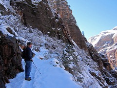
altRemember the words above?  I wrote them last Thursday.  Not only did we tackle a strenuous hike today, but we did in snow and ice.  The scenery up high is too tempting to ignore.  So, we purchased “Studded Snow Tires” for our feet (that is the name of the product, I did not make it up); and grabbed our hats, coats, and gloves.  Hiking up the narrow switchbacks was not bad, as long as you did not look down.  I was a little nervous coming back down, but the cleats provided ample traction.  We went up the cliff about three-quarters of the way.  Good enough.

Combined with another hike to Weeping Rock today (picture below looks out from underneath the Weeping Rock), we got some good exercise.

IMG_1365Besides hiking, we drove on up to the mile-long tunnel in the park.  The tunnel is very narrow and only 13 feet high.  Driving our truck through today, we had to pull the mirrors in to avoid hitting the tunnel side.  When we leave on March 8, we will make arrangements to drive through the tunnel in the middle of the road with our 5th wheel RV.  For $15, you are flagged through as one-way traffic.  Our RV is 12 feet, 6 inches high. 

You may wonder why we are here in the snow.  In late spring and summer, Zion National Park is hot and CROWDED.  After April 1, you are not allowed to drive your vehicle into the park; instead you are required to ride a shuttle with stops at the popular attractions. 

We would rather have chilly, but sunny days; and the freedom the explore the park without the crush of tourists.  By the way, our campground is 12 miles from Zion National Park with no snow and considerably warmer.

Thursday, February 24, 2011

Up

IMG_1353Zion National Park is one ginormous canyon with multi-colored cliffs reaching 3,000 feet.  As we drive through the park, our faces are cranked skyward and our necks are sore after hours of looking “up”.  Sheer cliffs with crazy rock climbers (look closely at the picture below—see the climbers?) and hikes that are carved into the rocky mountainside.  If you do not have a fear of heights, you will be afraid on some of these trails—narrow paths with loose sand and pebbles—sheer side up and sheer cliff down.  We may complete some of the moderate hikes, but the serious stuff we are leaving alone.

IMG_1352This time of year the Virgin River is full and has some energy behind the rapids.  Many of the trails parallel the river and you are able to enjoy the sounds of rushing water.  In fact, our campground is on the river and our site overlooks the water.  The location is good and bad.  In January, after 10 days and nights of heavy rain, the river flooded and the RV Resort was emergency evacuated at 2 a.m. in morning.  Hopefully, this is something we can avoid.

We are here until March 8.  With the exception of a couple of days, the weather looks warm and sunny.  Things are looking…..UP!

Related Posts Plugin for WordPress, Blogger...